Hidden Gems: 7 Secluded Campgrounds in the Pacific Northwest

The Pacific Northwest hides pockets of wilderness where you won't hear generators humming at dawn or wait in line for a shower. This guide reveals seven campgrounds scattered across Oregon and Washington that require a bit more effort to reach—but reward that effort with solitude, dark skies, and campsites where the only neighbors are Douglas firs and the occasional elk. Whether you're planning a weekend escape from Portland or a week-long road trip through the Cascades, these spots offer something increasingly rare: genuine quiet.
What Makes a Campground "Secluded" in the Pacific Northwest?
True seclusion isn't just about distance from cities—it's about access. These campgrounds share common traits: gravel approaches that weed out low-clearance vehicles, limited or no cell service, first-come-first-served policies that favor spontaneity over planners, and sites spaced far enough apart that you won't hear your neighbor's Spotify playlist.
The Pacific Northwest's geography helps. The Columbia River Gorge National Scenic Area and surrounding national forests contain thousands of square miles where roads simply don't reach. That said, seclusion comes with trade-offs. You'll need to pack extra water, carry a Garmin inReach Mini 2 or similar satellite communicator, and embrace the possibility that your "perfect" site might already be taken.
Where Can You Camp on the Oregon Coast Without the Crowds?
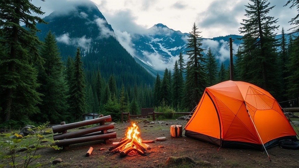
North Fork Campground in the Siuslaw National Forest offers 14 sites tucked along a tributary of the Siletz River, roughly 45 minutes from Lincoln City—but psychologically much farther.
The road in—Forest Service Road 1760—turns to gravel for the final six miles. You'll cross two shallow fords (passenger cars can manage in dry months; trucks handle them year-round). The campsites sit on a bench above the river, each with a fire ring and picnic table. There's no water source, no dump station, and absolutely zero cell service. The catch? You'll need to haul everything in and out.
The payoff is worth it. The North Fork Siletz runs cold and clear, home to cutthroat trout that rise eagerly to dry flies. Fallen cedar logs create natural seating around the fire rings. At night, the forest blocks any coastal light pollution—you'll see the Milky Way on clear evenings.
Nearby, Drift Creek Falls sits a half-day hike away. The 75-foot suspension bridge crossing above the waterfall makes for a memorable afternoon. Pack a Jetboil Flash for riverbank coffee and a copy of Campfire Stories: Tales from America's Last Wild Places for evening reading.
Are There Secret Campgrounds Near Mount Rainier Worth the Drive?
Most visitors to Mount Rainier National Park crowd into Cougar Rock or Ohanapecosh. But Forest Service Road 73 Dispersed Sites—technically outside the park boundary in the Gifford Pinchot National Forest—delivers Rainier views without the reservation wars.
These dispersed sites line Forest Road 73 south of the park, particularly between miles 8 and 14. There's no formal campground, just pullouts where previous campers have established fire rings. The Forest Service allows dispersed camping here for up to 14 days. You'll need a Northwest Forest Pass ($30 annually, available at REI or ranger stations).
The sites sit at 3,200 feet elevation—cool in summer, occasionally snow-dusted in late September. Morning fog often fills the valleys below, creating an island effect where your campsite floats above the clouds. Rainier's glaciated peak dominates the eastern horizon.
Practical notes: The road degrades after heavy rain. A Subaru Outback handles it fine; a sedan might scrape. Bring a RTIC 65 Quart Hard Cooler because the nearest ice is 45 minutes away in Packwood. Wildlife encounters are common—black bears frequent these slopes, so use bear canisters or proper hanging techniques.
Where Can You Find Lakeside Camping Without RVs in Washington?
Chiwaukum Lake in the Alpine Lakes Wilderness requires a 6-mile hike from the trailhead off Highway 2. That's the filter that keeps crowds away.
The trail climbs steadily through old-growth hemlock and cedar, crossing Chiwaukum Creek twice on log bridges. At mile 4, you'll reach the lake's outlet—good campsites here, but better ones await on the eastern shore. The final approach skirts a meadow exploding with wildflowers in July and August.
The lakeside campsites sit on granite slabs polished smooth by ancient glaciers. You'll need a Wilderness Permit (free, self-issued at the trailhead) and should practice Leave No Trace principles religiously—these fragile alpine environments recover slowly.
Fishing with a Patagonia Simple Fly Fishing Kit produces brook trout averaging 10 inches. Swimming is brisk—the lake stays cold even in August—but refreshing after the hike in. Worth noting: Campfires are prohibited above 5,000 feet in the Alpine Lakes Wilderness, so bring a MSR PocketRocket 2 stove for cooking.
Comparison: Pacific Northwest Secluded Campgrounds at a Glance
| Campground | Location | Access | Best Season | Key Feature |
|---|---|---|---|---|
| North Fork | Oregon Coast Range | 6 miles gravel | May-October | River fishing |
| FS Road 73 Dispersed | Gifford Pinchot NF | Gravel, rough when wet | June-September | Rainier views |
| Chiwaukum Lake | Alpine Lakes Wilderness | 6-mile hike | July-September | Alpine solitude |
| Beverly Beach Yurts | Oregon Coast | Paved | Year-round | Beach access |
| Takhlakh Lake | Gifford Pinchot NF | Gravel, steep | June-October | Adams reflections |
| Paradise Creek | Olympic National Park | 3-mile hike | May-October | Rainforest immersion |
| Billy Chinook | Cove Palisades SP | Paved, remote section | March-November | Canyon boating |
What About Camping Near Mount Adams or the Goat Rocks?
Takhlakh Lake Campground sits at 4,400 feet on the northwest flank of Mount Adams, roughly 35 miles from Trout Lake, Washington. The road up—Forest Road 24—climbs through dense fir forest before breaking into subalpine meadows where elk graze at dusk.
The campground proper contains 53 sites, but the seclusion seekers head to the Adjacent Dispersed Area—unofficial sites along the lake's eastern shore accessible via a rough spur road. These offer direct water access and unobstructed views of Adams' 12,281-foot summit reflected in the lake's morning stillness.
Here's the thing: Weather changes fast at this elevation. Afternoon thunderstorms are common in July and August. Bring a Big Agnes Copper Spur HV UL2 tent with a full rainfly, not just a tarp. Nights get cold even in summer—expect 40-degree temperatures and pack accordingly.
The surrounding area offers exceptional hiking. The Highline Trail connects to the Pacific Crest Trail, creating loop options from easy day hikes to multi-day backpacks. The Gifford Pinchot National Forest website provides current conditions and road status.
Can You Really Find Solitude on the Olympic Peninsula?
The Olympics draw millions annually to Hurricane Ridge and the Hoh Rain Forest. But Paradise Creek—a primitive campground in the park's Queets River valley—sees perhaps a dozen visitors per week.
Reach it via a 3-mile hike from the Queets River Road (itself a 20-mile gravel journey from Highway 101). The trail follows Paradise Creek upstream through old-growth Sitka spruce and western red cedar. Some of these trees exceed 300 feet tall and 1,000 years in age.
The campground itself—really just a few established sites near the creek—offers something rare: true temperate rainforest camping without the crowds of the Hoh. Moss drapes every surface. Banana slugs—some six inches long—traverse the forest floor. The creek runs cold and milky-blue, fed by glaciers on Mount Olympus.
Conditions here are wet. Not "might rain" wet—plan for rain. A Hilleberg Nallo 2 tent (serious waterproofing) and synthetic sleeping bag make sense. The Queets River Road frequently floods in winter and early spring; check status with the National Park Service before attempting the drive.
Essential Gear for Pacific Northwest Secluded Camping
- Water filtration: The Sawyer Squeeze handles creek and lake water effectively
- Navigation: Download offline maps through Gaia GPS—don't rely on cell service
- Fire starting: InstaFire Granulated Fire Starter lights wet wood in this damp climate
- Lighting: Goal Zero Lighthouse 600 for camp illumination without generator noise
- Camp seating: Helinox Chair Zero—worth the weight for rocky PNW terrain
Are There Hidden Gems in Central Oregon's High Desert?
Most campers speeding between Bend and Portland overlook The Cove Palisades State Park's Crooked River Arm campgrounds. These sites—particularly those in the Juniper Group Camp area converted to individual use in recent years—sit atop 300-foot basalt cliffs overlooking Lake Billy Chinook.
The geology here tells an ancient story. Massive basalt flows—flood basalts from 15 million years ago—created the canyon walls. The three rivers (Crooked, Deschutes, and Metolius) converge below, creating one of Oregon's largest reservoirs. The campground sits in high desert country—juniper and sage, not Douglas fir.
Sites 42 through 51 offer the best seclusion, perched on the canyon's edge with views west toward the Cascades. Summers run hot—90s are common—making spring (April-May) and fall (September-October) the sweet spots. The lake water warms enough for swimming by July.
Boaters appreciate the protected coves accessible from the Crooked River Campground boat ramp. Kayaks and paddleboards (the BOTE HD Aero inflates quickly) explore shoreline caves impossible to reach from land. The fishing—smallmouth bass and bull trout—requires a Oregon Department of Fish and Wildlife license.
How Do You Actually Get to These Places?
Logistics matter more with secluded camping. Most of these locations lack cell service for last-minute Google Maps checks. Download maps beforehand. Carry paper backups.
Fuel up completely before leaving pavement. The Toyota 4Runner and Jeep Wrangler crowd overlanders on Instagram, but a stock Subaru with all-terrain tires handles 90% of these roads fine. Just drive slowly and walk anything questionable before committing.
Water is the limiting factor. The Platypus GravityWorks 4.0L filter system works well for groups. Solo campers might prefer the lighter Katadyn BeFree. Either way, treat or filter everything—giardia isn't worth the gamble.
Fire restrictions change rapidly in the Pacific Northwest. August and September often bring total fire bans. A Jetboil Genesis Basecamp System provides reliable cooking regardless of fire status. When fires are allowed, keep them small and use established rings.
"The best campfire is built slowly, with attention to each layer—tinder, kindling, fuel. Patience rewards you with flames that last until morning."
The Pacific Northwest's secluded campgrounds won't stay secret forever. Instagram geotags and overlanding YouTube channels expose new places constantly. That said, the physical barriers remain—the gravel roads, the hike-ins, the lack of amenities. These filters protect the experience for those willing to work slightly harder.
Pack the truck on Thursday evening. Leave before dawn Friday. Stop for coffee in some small logging town where the barista knows everyone's order. Turn onto that gravel road with confidence. Set up camp, gather wood, light the fire as shadows lengthen. Watch the stars emerge—more stars than you've seen in years. This is why you came.